BLENHEIM to CHRISTCHURCH ... almost!
Easter Monday we went to check on Rosy from the vet's where she'd been boarded. When I caught her I noticed her nearside back leg was cut and bleeding. Some years ago Rosy had been badly injured on both hind legs and the scar tissue was always susceptible to grazes, doing extensive damage.
After treatment the vet said she was sound and at 10am I left on the three day ride to St Arnaud. I left Brae with Kerry, my host, as a temporary arrangement - this was a learning experience for me in the busy traffic, and I couldn't have coped with two excited dogs as well.
We crossed State Highway 1 and I began riding west along the main road towards Renwick. Marlborough is a delightful part of New Zealand - and late Summer the colours were intense. To the right of me were blue mountains, to the left the mountains had been scorched brown. The trees of the shelter belts, many of them poplars and willows, were showing their golden Autumn tones, whilst the fruit was ripe and being picked.
Grapes for wine or table, berries of all sorts, marvellous crops of apples and plums. (Okay! It was me, I stole one!) I stopped to chat to an orchardist to inquire why there were so many windfall apples under his espalliered trees, and he told me that when they pick they lose half of the crop because they grow so thickly in bunches. He kindly gave Rosy some of the windfalls, whilst I was given some of the "firsts".
Soon after I remounted Rosy, but the saddle slipped and the horn hooked under my bra.
Picture me, suspended by my bra from the saddle, with just my toes touching the ground! My T-shirt was nearly being wrenched off - as were my breasts, the skin underneath was beginning to tear, and so rather than ask someone to assist (not that any of these rushing motorists were interested in what I was doing, dangling there from my horse) I decided to tear my bra and free myself.
Oh dear. For a well-endowed woman it is NOT comfortable horse-riding without a bra. I needed to find a bra shop - and quick. But I was about 8km out of Blenheim, with a horse and dog.
Across the road was a house and garden, and I went to ask if I could leave Rosy and Zig there. We put them in a potato paddock next door, and on hearing my plight Daphne Boone offered to run me back into Blenheim to the shops. She whizzed me into the shops, waited whilst I made my purchase, and returned me within minutes to my animals. Much more comfortable I started off again along Old Renwick Road.
 A dry riverbed was filled with California Poppies, brilliant orange in the Summer sun. Beautiful! We sat and rested in the Summer sun, before finally getting to Renwick, which was only 10km from where we had left - and this was 3pm! We were NOT going to get 30km in one day at this rate. With Zig squatted in the bottom of the telephone booth, and holding Rosy outside, I found a local pony club father who agreed to transport us to the 20km to our first night's stop.
Mark Giles and Nikki Satterthwaite have a delightful property in the Wairau Valley. They have recently built their own house with wonderful views of the mountains framed by the lush green of their paddocks and bush on either side. Nikki is now working at creating a cottage garden, which will look magnificent around the Australian bush-style house with its large verandah. Both Nikki and Mark have lived in the Marlborough area for many years, and were interesting commentators on the larger mountain stations in the area.
Next morning I planned to leave early, but firstly I made the decision to send Zig back to boarding kennels in Blenheim. This was the second hardest thing I'd done... but I was only learning - there hadn't been adequate time to plan and train for this ride
We left Nikki and Mark's place at 10am and it was 30km alongside the Wairau River to The Branch, a large station beside The Branch river. Soon after I started the Rural Delivery postman came along, and we chatted about his work. He reminded me that the markers beside the road with the numbers on actually showed the distance in kilometres, so I was able to measure my distance. This was a big help, and I timed Rosy over a kilometre and discovered she was walking at about 6km an hour - which is quite fast. Fast, and yet it's pleasurable to be able to look down from her great height - she's tall for a horse, 16.3 hands - and into people's gardens, or over a fence and discover a pond that motorists or cyclists would only whiz by and not know about.
Another point which is useful on the NZ roads... the marker posts on the left-hand side of the road have one long and narrow reflective strip, and on the right, especially on corners, the markers have two short fat reflective strips (actually coloured yellow... but that doesn't show up at night). When we used to compete in car rallies we could tell whether the corner ahead was a long one or tight one, and went to the left or the right. Only one or two markers showing would indicate a tight corner, three or four a gradual bend. Short fat reflectors would indicate that the corner went to the left, long skinny reflectors that the corner went the other way.
This was a lonely road, and made me realise just how vulnerable we are. At times I could look all around me, for miles up ahead and behind, and there was no sign of human habitation, except the odd farm animal. There was an interesting mix of farms along the way. Merino sheep and Romneys, beef cattle, a paddock with alpaca, deer...
From time to time there were rental campervans plying back and forward; I tried to guess at the nationality of the people in them. Everyone had a bright wave, and most vehicles pulled right across the other side of the road and/or slowed down, not that Rosy bothered. Nothing concerned Rosy... apart from the gremlins and trolls she believes live under bridges. But as we travelled she was getting better and better. We came across a delightful one-lane bridge with the framed top and sides, but there was also a ford beside the bridge so I made Rosy wade through the river. THIS was almost worse than crossing a bridge!
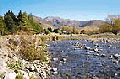
The landscape didn't change all that much. The Wairau River was slow, very wide and stony after the long Summer. The mountains to the north were blue and black, whilst the range to the south of me, on my left side, was brown and green. I guess the Wairau River was about one mile wide, with a mile of pastureland on either side, and then steep mountains. I learned today that the Wairau River is right on a fault line - numerous small earthquakes happen each day, fortunately all too minor to be felt although they register on a seismograph.
By 4pm I had crossed The Branch river and had reached the night's destination, a farmhouse that I'd phoned several days before to ask if they knew of anywhere I could stay the night and leave my horse.
It was another 30km through much the same scenery, but now the river was running wild. It was amazing how much it had changed overnight. The mountains are so tall that the streams must fill quickly. As the rainclouds lifted slightly there was white mist hanging in the folds of land, accentuating the outline of hills and mountains. Such scenery! Wildflowers beside the road... Vipers Bugloss, Verbascum, yards of Yarrow, yellow Hawksweed... beautiful.
There are so many advantages in seeing a country from the back of a horse... You can appreciate the depths of the forest, and hear the bird calls. You see the brooks that tumble underneath the road you are riding on. At one stage we passed a large pond that no motorist would know exists. The geese on the pond were rather startled to see a horse go by, and all flew immediately into the air, with loud and continuous honkings as they sailed into the distance.
And I loved the antics of the sheep when we rode past - quite often all of them would stand and watch, until one decided that "Rosy meant danger", at which point all of the sheep would turn around and run away. At one stage there was a flock of Merino rams watching, all with their curly horns. An unusual sight!
I experienced a huge range of emotions as I rode... probably caused by my solitude. I felt depression (at having to leave the dogs behind) and elation at the fact that I was finally doing what I'd dreamed about for so many years. Physical pain as I pushed my body, both riding and walking. Joy at seeing the things I'd been seeing. Humour at the animals and their reactions to my encroaching their territory...
After five and a half hours' riding (and occasionally walking beside Rosy to give her a break) we rode alongside the beautiful Six Mile Bush Reserve which is mature beech forest, a sight to see as it dripped rain down into the misty clouds. Shortly afterwards we found the Top House road in the clouds, with a fine mist settling on us as we went along.
Whilst waiting at Top House for Lawrie, Lee and Jenna to arrive I'd been able to retrieve Brae and Zig from Blenheim. I was delighted to see them, but Lawrie wasn't so keen to have them about.
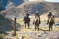
Lawrie was a horseman or wrangler from "way back". At 67 years of age, he was still very active in the world of Western riding, having performed successfully in the Finals of the Western Roping competition the weekend before. He had grown up on a Totara Flat farm in Grey Valley, Westland, and recalls days of a dependence on horses as being the only link with civilisation.
"My father packed (on horseback) a wood-burning stove 14 miles through the bush so that my mother didn't have to cook over an open fire", he recalls. "We used horses because we had to. We couldn't get through rivers without them, and the only way of moving stock up and down the valleys was along the riverbeds."
"I learned all about droving whilst I was at primary school, and guided a fishing trip for a group of city doctors when I was only 11 years old. They wanted someone who knew the track, so I got the job."
He worked as a blacksmith in Waimate and Nelson, and served as huntsman in Brackenfield, Southland for ten years, later Master of the Hunt in North Canterbury.
It was in the late 1950's that he became involved in rodeos, working as the pick-up rider. When the bell had sounded for the end of a ride on a bucking horse, the pick-up rider takes his own mount alongside the competitor and helps him off the horse. He got into calf-roping in 1966, riding his own quarter-horse.
In 1973 Lawrie and his cousin, Don, were contracted by the NZ National Parks Board to remove the wild cattle off Farewell Spit in Nelson. At the age of 60 he won the national title for team roping - so he's now tried just about every form of equestrian sport.
Lee Oldfield, a trekking guide from another operation near Nelson, brought Jenna Knoop and her mount, Cherry, with him in another truck and trailer, as well as all the food and camping needs we were going to need for the next few days.
Lee had spent ten years involved in endurance riding, so was also able to give me great advice. Jenna proved to be a very bright and entertaining riding companion.
It was a short journey down to the start of the Rainbow Road, and through a locked gate onto the Rainbow Station, 68 thousand ha (28,000 acres) of beef and sheep extending south down the Wairau River valley. In the 1950's the NZ Electricity Department put through a road so that they could build power transmission lines between Hanmer and the Rainbow to carry electricity north from the power-generating lakes. This was the road that we would be following, although Jenna and I soon found there were many places where we could ride cross-country.
At first our path wound through puddles and beech forest. At a smart walk we laughed about our mutual dislike of dictator-type knowledgeable people, and exchanged jokes and experiences. Jenna is of German extraction, had spent several years working in shearing gangs, on prawn trawlers and as a topless waitress, so you can imagine the fun we had!
Recently she had been studying horsemanship under Pat Parelli, and was riding her part-draught mare Cherry with only a halter, and a Western saddle. They enjoyed popping over fallen logs and rain-filled ditches, up and down banks as they rode. I concentrated on keeping Doug behind me and Rosy underneath me!
Our support crew were waiting at one rain-filled ford with refreshments and more advice, and then left us to the wilderness of the craggy, beech-covered mountains. These passes were used by the Maori hunters, and later high-country graziers to move mobs of sheep between Canterbury and Nelson and Marlborough, leaving behind them a chain of cob (built from mud) houses.
We passed the access to the Rainbow Skifield (17 km into our day's journey) which is being rapidly commercialised and is becoming more and more popular with Wellington skiers, who find it more easily accessible than the North Island fields.
Some of the fords, after three or four rainy days, were running quite strong, but Rosy soon learned to force her way forward against the current. There was nothing quite like this back at home - the rain usually meant mud!
However, Doug was not so brave! Several times he stopped on the brink, and as Rosy plunged forward I became stretched in the middle until I had to drop Doug's lead rope. Then we would have to go back and get Doug, and I'd get on again. Finally I learned to wrap a fold of the rope around my saddle horn.
We were rising gradually now, but at one stage the road suddenly turned right, and wound left again in a tight hairpin bend to quickly bring us down and across a bridge over a rocky fissure, filled with water toppling and tumbling down to the main river many, many feet below us. I was glad of the good sense of our horses - this bridge had no sides!
The rocky mountains were close to us now, with overhangs into which the road had been cut. Don't think of earthquakes happening now!
We rode across more grassland, meeting a drover, his heavy horse and gang of dogs, bringing a mob of young steers back to the main farm.
"Morning", I called. There was no reply.
The Rainbow Road has become very popular lately with trampers, horse and mountain-bike riders and "tourists" out for a four-wheel drive experience. Unfortunately though, these tourists bring their own problems with them. Many come poorly provisioned for nights in the mountain cold, and what they would consider an emergency is often something that planning or experience would have prevented.
An important rule of the country is to leave gates the way you find them. However, many people don't ensure that gates are closed securely when they close them. They don't realise - or don't care - what a job it can be to retrieve stock out of a paddock, especially one where there's no boundary fence. Or, to separate your mob from the neighbour's herd. Gates should be left alone when they're already open, and left shut securely when they're found closed.
The station-holders keep their boundary gates carefully locked too. Instead of applying for a key, as they request visitors to do, some people just take along bolt cutters, feeling it's their right to use the road. Now the stations have to invest in new padlocks frequently.
This all puts pressure on people who make their livelihood from farming, not rescuing or remedying, so there are valid reasons why the station-holders are not happy with the tourists. It's this abuse that is putting the right to enjoy the Rainbow Experience at jeopardy. And possibly the reason why the drover ignored us.
After riding for about five hours through magnificent scenery, we passed a cob cottage, the original Rainbow Homestead, with two musterers' hacks in what was formerly the garden and rows and rows of dilapidated kennels on the other side of the road. Dogs and horses played an important part in the establishment of these high country stations.
In the yards near the old house the stockmen were drafting out Hereford cattle. The holding paddocks were a sea of mud; we were so lucky that the weather had cleared up for our trek.
We had covered 30km and had arrived at our first night's camp at Connors Creek. On the northern edge of the creek, and 1km into the dense beech forest the Department of Conservation hut had six bunks and was available on a "first come, first served" basis. Fortunately, we were the only ones that wanted to use the facilities that night, so after fencing off the horses in a clearing, where they could access the river for water, we prepared to cook dinner and sleep the night. I went for a walk and found that I could have climbed to the top of the beech forest 'bush'... in about three hours. I decided not to make the journey!
Whilst Lawrie took care of the horses, Lee, the unofficial cook and trek manager, prepared the dinner. We had a delicious meal of sausages, with bacon and mushroom lasagne sauce, roasted wild pork (cold), and mixed vegetables. After the long day, it was superb.
Although the camp had a toilet, the nearest bathroom was the rushing river nearby. It was cold! We were all in bed before dark and up with the dawn.
We quit camp at 8am and crossed the river we'd camped next to - one of the deepest fords of the ride. The horses tackled it with ease. The road was easy and we trotted along because today we had a long ride. A few kilometres later we crossed a long and narrow, wooden bridge - once again, no sides, over the Wairau River. To our right the Rainbow River rushed down to join the Wairau.
Now we began climbing, on the other side of the Wairau, and went through 'Hell's Gate', a narrow gorge. Around the corner sunlight was spilling into the next valley, lighting up poplar trees in their Autumn splendour beside another narrow bridge over Coldwater Creek, with camping sites nearby.
With Lee riding Doug, Lawrie now driving the truck, the road climbed up steadily to the boundary between Rainbow and Molesworth Stations. The scenery had changed to a classic South Island landscape of rounded, tawny-coloured hills, scrawny matagouri, red hips on rose bushes, long screes and a beautiful azure sky. The colours were magnificent.
Screes are deep slopes covered in loose shingle; if you were going to paint these mountains you would want every different shade of brown imaginable in your palette.
 The road wound down from the mountains to cross the Wairau River again and we had lunch near a small hut set up for Electricorp workers. This was now alpine country with tussock and many rock plants. I could only remember this landscape once before - on the Desert Road, in the centre of the North Island. I was told that nearby were the beautiful Tarndale Lakes. The very fragile wetland communities made good studying, and there was good fishing as well.
The mountains around here had all been named during the European exploration in the 1850s at the time of the Crimean war - Turk Ridge, Mt Balaclava, the Crimea range.
We had now ridden another 18 km and I was feeling the pace! Lawrie and I swapped and I took a turn at driving the truck.
Passing the road to Island Gully Hut I pushed the truck up to Island Saddle. At 1347 metres, it is the highest point on the Rainbow Road and the watershed between the Wairau and Clarence Rivers. We had now travelled some 59 kilometres and I decided to wait at the top for the horses.
I sat there and appreciated the "big" country. I was the only person for miles. I waited. They should be here soon.
High above me, a jet soared towards Christchurch International Airport, leaving a trail of white in the clear blue sky. The sky was unusual... azure around the horizon, but a deep, dark blue above me. Did this mean snow was coming?
I looked again for the horses. I should be able to see them at the bottom as they came around the first bend. Still nothing. I had now been waiting for thirty minutes. If... If something happened, if someone came, what would I do? There was no-one, nothing. How insignificant I was. Just a drop. The people in that jet were probably the closest people around.
Still there were no horses coming around the bend at the bottom.
What if something had happened to the horses? Could I turn the truck and the float? Should I go back... or should I go on towards Hanmer?
I tried to do some calculations. If only I'd measured the distance that I'd driven AND noted the time I'd left. It only looked a kilometre to the bottom of the valley... but suddenly I noticed a dot, moving. It was so tiny... was it a horse? A few minutes later the dot disappeared around a bend and then emerged and was, I thought, two horses. As the road wound out of sight and back again, I could now clearly see two brown horses. So where was the third? Cherry was a bright bay (brown with black mane and tail) whilst Doug was a dark bay. Rosy was a chestnut, no black on her. I couldn't make out what colour the two horses were.
Again, they came into sight. Yes! It was only two horses, and there was no sign of a third. But ten minutes later I clearly heard the clip-clop-clip-clop of one horse!
And there was Doug, a clear five minutes ahead of the other two which were still halfway, walking up the long hill. Doug was ambling, a sort-of shuffling gait which is the choice of those who like to cover long distances. Lee told me that Lawrie and Jenna had got deep into a friendly argument as to the finer points of horsemanship, both favouring their own methods, so he'd let Doug have his head and ambled to the top.
Good old Doug! He wasn't even hot.
Within 5 km of the Summit we had descended again to river level, across another bridge and then a short rise to the turn off to Lake Tennyson. I had been told how beautiful the lake was, so Lee agreed to drive me the few kilometres out to see this scenic gem.
The lake has camping sites, but it not particularly favoured as a long-term camping area as there are many sandflies and it's also very cold at nights. It was formed by a glacier-deposited dam of rubble, and Lee told me that the level of Lake Tennyson can rise or fall several metres after an earthquake.
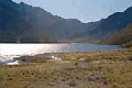 The water was clear and very icy to drink. I heard the story of a horseman who took his horse into the lake. A few metres from shore the lake drops steeply, and the horse went out of its depth. The rider survived - the horse was recovered when it came to the top ten days later.
To the west is Mt Una (2301 metres) highest point in the Spenser Range. Many of the peaks in the Spenser Range are named after female characters in Edmund Spenser's classic 17th century poem, 'The Faerie Queene'.
We now followed the Clarence River, with its origins at Lake Tennyson, all the way to Fowler's Creek and the small hut which was to be our overnight accommodation. Compared to the other DOC hut, this was extremely primitive. The toilets were the saplings at the back against the mountains, and the water was a good walk away at the river. There was a paddock for the horses, though, and they didn't object.
 The next morning we were on the last leg. We were riding all the way to St James Station - at 85,000 ha (200,000 acres) it is one of the largest privately-owned stations in New Zealand. We arrived in time for their biennial Horse Sale. Afterwards the road through to Hanmer was very busy with traffic, so Lee and Jenna agreed to take the three horses through Jack's Pass, a steep descent, dropping some 500 metres to the Springs.
I felt quite sad as we left the Clarence River Valley. It had been quite an adventure, coming down the Rainbow Road. We passed the road to Molesworth, the old settler's route back to Blenheim over private land. It's open for two weeks each Summer, and it had been my original intention to ride this way to Hanmer. But the Rainbow could not have been better.
The next stage took me through towards the Lewis Pass, where I was to meet another Lawrie who ran Alpine Horse Safaris. Lawrie and Jenny were keen to show me their country. So I arranged to ride to a station called Glynn Wye, where I would meet the O'Carrolls the next day.
Rosy, Doug and I travelled south, over the Hanmer River, then through a steep, deep gorge and across the very narrow (one-way) suspension bridge, the Waiau Ferry Bridge, past some about-to-be bungy jumpers.
The route to Springs Junction was a good, wide road alongside the river, with considerable heavy traffic and tourist-type vehicles, campervans, caravans, rental cars, but the verge was wide and the views of the Waiau breathtaking.
I stopped on occasion to listen to the bellbirds, and came across a patch of clover and chicory - the horses didn't admire the beautiful blue and purple flowers but enjoyed them for lunch instead! After riding for five hours, and just on darkness, Glynn Wye appeared in the gloom.
This station is owned by Cliff and Lorraine Cox and is managed by their two sons, Clive and Mike. Covering an area of 24,300 hectares or 60,000 acres it runs something like 16,000 sheep, 1,400 cattle and 1,400 deer. The numerous houses on the property give the appearance of a small village!
John Macer, Head Shepherd and Clive joined us for breakfast the next morning before Lawrie and Jenny arrived, with one of Lawrie's specially bred horses, Bracken.
Lawrie and I left Glynn Wye, heading south away from the road, and climbed directly south for 2-1/2 hours until we came to the summit of the Little Organs Range where we stopped and ate our lunch gazing at magnificent views - the large flat paddocks above the Glynn Wye Station, the Boyle, Doubtful, Waiau and Hope Rivers, from Hanmer Springs in the east to the Lewis Pass in the west, and the Spenser and Hanmer Mountains. Highest points were Mt Captain, the Dillon Cone, Mons Sex Millia, and the Castle, although they didn't look any higher than where we sat!
 From the summit there's only one way... down. And descend we did. We were now following a mere pack-track, carved out of the slope by horses - narrow and slippery. Rosy kept charging past me, so Lawrie led both Bracken and Doug, and I let Rosy go loose.
I dawdled behind, taking photographs, and heard a shout from Lawrie. As fast as I could I came over the top of the edge, and looked down to see just the back of Rosy submerged in a steep creek, whilst Bracken and Doug stood looking disdainfully down at her from above, on the track.
Lawrie hauled the saddle off and dumped it on the track, asking me to lead Doug and Bracken onwards to where the track stopped on a grassy slope. Somehow, he managed to coerce my horse out of the mud and she stood pitifully, holding one hind leg up, back on the track.
It wasn't long before we had Rosy resaddled, and she seemed to be okay. We began the downwards journey again. At times we could ride, at times we led the horses. Finally we arrived at the Gorge Creek Saddle, where we stopped for a breather and then rode down into the beech forest of Darkies Gully, along another packtrack to arrive at the delightful Valley Camp Hut, in the lea of Mt Skedaddle. Now we were on another station - Island Hills, 6,850 ha (17,000 acres).
The track out the next morning followed the Organ Stream down through manuka and onto the Mandamus River. Beautiful country, which can only be really appreciated from the back of a horse.
 We crossed the Glencoe, wound past the Island Hills homestead and down beside the Dove River, shortly crossing the Mandamus again, under a suspension bridge, past another large station, Glens of Te Koa, set in beautiful mature trees. The Mountain Ash and Hawthorn berries, against the
stone cliffs of the narrow gorge were a picture.
We crossed the Glencoe, wound past the Island Hills homestead and down beside the Dove River, shortly crossing the Mandamus again, under a suspension bridge, past another large station, Glens of Te Koa, set in beautiful mature trees. The Mountain Ash and Hawthorn berries, against the
stone cliffs of the narrow gorge were a picture.
Now we rode alongside the huge Balmoral Forest, and then cut through the pines down to the edge of the Hurunui River. Lawrie wanted to ensure we could safely cross, not being sure how my two horses would cope with the current, so he had arranged for Jenny to bring down a horse, 'Kestrel', to meet us. If necessary, he would have had me ride her across, but the water was not too deep, nor the current too fast, so the three of us rode across, the water swirling around the horses' shoulders.
Emerging from the bouldery bed of the river, it was a short trek to the well-organised stables of Alpine Horse Safaris. Rosy and Doug were pleased to be here, greeted by a hard feed, a hosing down and a sheltered, lush paddock when they were dry.
I left Waitohi Downs after receiving good advice from Lawrie O'Carroll on how to pack a packhorse. Good advice... because as we trotted along the edge of the road towards Hawarden, Doug's load looked most secure, so much so that we enjoyed a canter together along on the flat. The roads of Canterbury are wide, straight and flat, with even wider verges which make horseriding a treat. Lawrie had also shown me a short cut along the Peaks Road.
It was a very hot day, and the horses were delighted to reach the ford across a small river. It was tempting to stay there with the horses' legs in the cool water, but we pressed on knowing that the saddler in Hawarden was expecting us.
Passing the little brick office which had once been part of the 122,000 acre Horsley Down estate, it was easy to imagine the estate workers lining up to be paid. The office was quite detached from the house. We couldn't have them coming too close to the house, now, could we!
From Hawarden to Waikari was only short, but it was delightful country, quite flat, with a few gently rolling hills, lots of old English and poplar trees, all changing colour, and limestone outcrops - the colours and tranquility of an Autumn landscape.
Andy and Mandy Roberts, whose father's property was the site of the Sheepdog Trial Course, had offered to graze my horses overnight. They lived on a smaller farm right in Waikari.
I sat outside on the terrace of the pub, in the evening cool and watched the delightful sunset. A perfect end to a delightful day. The next morning dawn was beautiful too.
As I walked along the disused railway embankment, dogs barked at this 'interloper' intruding in no-man's land. I was pleased to see my two horses in the paddock next to a house which looked suspiciously like Andy's. It's a bit of an adventure exploring a new route, but it had proved to be fun... and considerably shorter.
Having enjoyed the cross-country walk, I had made inquiries of people who lived along the Old Weka Pass Road as to the possibility of tracing the footsteps of the earlier pioneers. They were happy for me to do so, and I went back one kilometre towards Hawarden to find their gateway and the long-forgotten Weka Pass.
It's though the Weka Pass was first visited by NZ's earlier Polynesian settlers about one thousand years ago, when it would have been covered in deep forest. The Moa Hunters, as they were known, would have come to hunt the birds that were abundant in the forest.
There were, I found out later, historic rock drawings here, between 500 to 1000 years old. The large overhanging limestone shelter was used as a temporary overnight camp. Whilst staying there they would draw on the shelter walls, using charcoal from their campfires, and red ochre.
The Moa Hunters burnt off the bush as they hunted, but when the Europeans came in the 1860's they found the pass which created an important link to the goldfields of the West Coast. I was told that at one stage over a period of three weeks 25,000 men were counted making the journey through the pass westwards!
It was a delightful trek cross-country, even if we did have to open and shut gates on the farms over which we rode. Rosy frequently got 'spooked' by the limestone outcrops too.
Arriving at the other end of the Weka Pass I found the owners waiting for me. They were concerned that I would still have 2kms of extremely busy and narrow road to negotiate, so he very kindly followed me in his car, with orange lights flashing to warn motorists to slow down. It was a busy Sunday with many travellers returning from Hanmer Springs, so I appreciated his efforts greatly.
It was then a simple ride along long straights with wide grass verges to Waipara. But Rosy was unhappy, becoming increasingly difficult to mount again when I had got off. I found a shortcut, once again the old road, fording the Waipara River and taking a 'no exit' road which brought me out alongside the railway lines.
As we emerged by SH1 again, the weather changed dramatically. Stormclouds were coming down shrouding the Alps... I needed to get into Amberley quickly and find some overnight grazing and accommodation.
I scouted around from the no exit road, not wanting to go back the long way, until I found somewhere where the fence was low enough to lead the horses across the main trunk railway. I hoped that no trains would come along!
I tied the horses up in the gateway to a farmhouse, and walked up the stately drive. Wayne and Fiona Jesson offered to accommodate the horses and me until we could make alternative arrangements.
Rosy was sore. Not only were her back legs continually getting injured, but her wither was now sore from adjustments to the saddle. I looked for an alternative mount, and found D'Artagnan, a 15 year old, 15.2 hh grey gelding who had been used by beginners in riding schools.
It was D'Artagnan that I would send to Bluff with Doug, and Lisa's horse, Tom, to begin the second part of our journey.
© 1996/97 Jacqui Knight, all rights reserved.